

Local Sites
Local Sites
Better yet, take up underwater photography as I did. I find it much more challenging and rewarding - and there are no limits, licenses, or seasons to worry about.
· Only take what you can eat that night. Rockfish and lingcod are far better when fresh. Please do not fill your boat simply because you can or are within you limit, especially in the Cape Flattery area.
· Never shoot an orange or red colored rockfish. Two orange colored species in our waters are protected or endangered (yelloweye and canary rockfish). The orange colored rosy rockfish is an exceedingly rare find and should be left for other divers to appreciate.
· Leave the bigger fish alone when hunting. Big fish tend to produce far more offspring than small fish. Some rockfish species dont reproduce until they reach an age of 14 years.
· Dont shoot cabezon. We see few of these giant sculpins outside of Edmonds Underwater Park. Please let them recover. The same goes for China and tiger rockfish in the San Juan Islands and Cape Flattery area and black rockfish anywhere outside of the Cape Flattery area.
·Wolfeel and octopus are icons in our area that are idolized my almost all northwest divers and should be left alone. I would actually fear for a divers well being if he or she speared either of these animals and dragged it ashore among a group of northwest divers.
Western Strait of Juan de Fuca
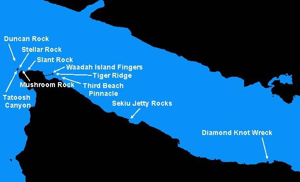
The far western reach of the Strait of Juan de Fuca (which I refer to as the Cape Flattery area ) is the diving showcase of northwest Washington. Many of the dive sites in the Cape Flattery area are on par with world class dive destinations.
The far western reach of the Strait of Juan de Fuca (which I refer to as the Cape Flattery area ) is the diving showcase of northwest Washington. Many of the dive sites in the Cape Flattery area are on par with world class dive destinations.
The incredible underwater topography of this area is outclassed only by the robustness, diversity, and density of the marine life. The Strait of Juan de Fuca empties into the Pacific Ocean and draws up cold and nutrient rich waters from below, starting a rich food chain. This is the only place in the state where I regularly see large schools of black, blue, and yellowtail rockfish. I usually note at least eight species of rockfish on most dives. Wolfeels and octopus thrive in this rich environment. Chance encounters with grey whales, humpback whales, and stellar sea lions are a distinct possibility. However, it is the kaleidoscope of colorful invertebrates that make diving Cape Flattery a very special place. From deep gold and purple-ring topsnails to vibrant urticina anemones as big as dinner plates, the Cape Flattery area has it all.
The majority of the dive sites in the Cape Flattery area consist of hard rock formations situated on broken shell substrates. Massive spires, pinnacles, walls, boulder fields, caves, and ridges are commonplace and provide excellent habitat for fish and invertebrates alike. Dense kelp forests populate most areas where underwater structure comes within 30 feet of the surface. The underwater seascape is like nothing else in our area.
Underwater visibility in this part of the state varies greatly depending upon plankton blooms, current, swell, run-off, and weather. Typical visibility is 25-30 feet during summer. Visibility in the spring tends to degrade to 15-25 feet, but by July it improves markedly. I have had many dives in this area with visibility exceeding 40 feet.
Water temperatures in the area are somewhat colder than elsewhere in the state. Summertime water temperatures are usually in the 42ºF-45ºF range, which is about 10 degrees cold than Puget Sound summertime water temperatures.
As nothing is free in diving, access to this scuba showcase only comes at a price. The Cape Flattery area is remote. It takes about 5 hours to drive to Neah Bay from Seattle, traffic permitting. The town of Neah Bay is part of the Makah Indian Nation and provides a below average boat ramp, fuel dock, excellent marina, a few restaurants, and a decent general store. Motel accommodations in Neah Bay are a bit too rustic for me, so I prefer to stay 18 miles to the east in Sekiu. Curleys Resort in Sekiu has a compressor for air fills. Snow Creek Resort also offers air fills closer to Neah Bay.
Remoteness aside, it is the exposure of the Cape Flattery area that discourages most divers from venturing to this corner of the state. All of the dive sites are wide open to the Strait of Juan de Fuca or Pacific Ocean. To better the odds, I only visit the Cape Flattery area during summer months (June-September) when the weather is more calm and predictable. I time my visits to coincide with optimal currents, ideally when the maximum current during the main part of the day is 1.0 knot or less at the Strait of Juan de Fuca entrance. Despite these precautions, I normally encounter a 4-6 foot swell and current at many of the dive sites. The swell becomes more pronounced along the strait towards the ocean. I have done dives at Duncan Rock in 10-12 foot swell and have been able to feel the swell as deep as 80 feet.
Weather plays a major hand in dive planning, even in summer. Although I have had days when the water around Cape Flattery is like glass, winds and storms can whip up in a hurry. Thick fog can roll in a moments notice or may just hang around all day, even in summer. I would never come to this area without a good GPS mapping unit.
Current in the strait and around Cape Flattery is unforgiving and potentially very dangerous. I have personally been carried away by current on two occasions. Both times the boat operator lost track of me even though I sounded my dive alert and deployed a 6 bright red signal marker buoy. My buddy and I were fortunate on both occasions that another boat was close by and quickly came to our rescue. I now carry a submersible mini-VHF radio in a watertight Otterbox in my dry suit pocket in case I find myself in a similar situation.
The bottom line is diving this area is not for everyone. It is at a minimum advanced diving. I like to call it extreme adventure diving. I know people that have driven all the way to Neah Bay, rode the boat to Waadah Island just outside of Neah Bay, and refused to get in the water. I respect them for knowing their limits. However, the diving here is second to none on those days when conditions are right.
Click on a dive site name on the map to view the dive profile.
Local Site Maps
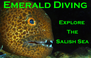
Emerald Diving
Explore the coastal and inland waters of
Washington and BC
Explore the coastal and inland waters of
Washington and BC


Other Resources: